East Anglia

- East Anglia is often used as a shorthand for the Kingdom of the East Angles.
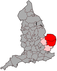
East Anglia is a traditional name for a region of eastern England, named after an ancient Anglo-Saxon kingdom, the Kingdom of the East Angles. The Angles took their name from their homeland Angeln, in northern Germany. East Anglia initially consisted of Norfolk and Suffolk, but upon the marriage of the East Anglian princess Etheldreda, the Isle of Ely also became part of the kingdom. Formerly a standard statistical region, for administrative purposes East Anglia now forms part of the East of England government office region and is defined as a Level 2 Nomenclature of Territorial Units for Statistics, comprising the counties of Norfolk, Suffolk and Cambridgeshire including the city of Peterborough unitary authority area.[1]
Contents |
History

The Kingdom of the East Angles, formed about the year 520 by the merging of the North and the South Folk (Angles who had settled in the former lands of the Iceni during the previous century) was one of the seven Anglo-Saxon heptarchy kingdoms (as defined in the 12th century writings of Henry of Huntingdon). For a brief period following a victory over the rival kingdom of Northumbria around the year 616, East Anglia was the most powerful of the Anglo-Saxon kingdoms of England, and its king Raedwald was Bretwalda (overlord of the Anglo-Saxons kingdoms). But this did not last: over the next forty years, East Anglia was defeated by the Mercians twice, and it continued to weaken relative to the other kingdoms until in 794, Offa of Mercia had its king Æthelberht killed and took control of the kingdom himself.
The independence of the East Anglians was restored by a successful rebellion against Mercia (825–827), in the course of which two Mercian kings were killed attempting to crush it. On 20 November 869 the Danes killed King Edmund and took the kingdom, which they named East Anglia (see Ivar the Boneless). The Anglo-Saxons retook the area in 920, only to lose it again in 1015–1017, when it was conquered by Canute the Great and given as a fiefdom to Thorkell the Tall, who was made Jarl of East Anglia in 1017.
Much of East Anglia (including parts of Lincolnshire) consisted of marshland and bogs until the 17th century, despite the construction of early sea barriers by the Roman Empire. During the 17th century the alluvial land was converted into arable land by means of systematic drainage using a collection of drains and river diversions. In the 1630s thousands of Puritan families from East Anglia settled in the American region of New England, taking much East Anglian culture with them.[2] East Anglia, with much of its earnings based on wool and textiles, was a rich area of England until the effects of the Industrial Revolution moved manufacturing to the Midlands and the North.
During the Second World War, the RAF and the United States Air Force constructed many air bases in East Anglia for the heavy bomber fleets of the Combined Bomber Offensive against Nazi-occupied Europe. East Anglia was chosen because it had considerable open space and level terrain and it was relatively close to mainland Europe, thus shortening flights and allowing for greater bomb loads. Remnants of some of these bases are still visible. Pillboxes which were erected in 1940 to help defend the nation against invasion can also be found throughout the region at strategic points.[3]
Geography
Much of the area is characterised by its flatness, partly consisting of fenland and reclaimed marshland, though much of Suffolk and Norfolk is gently rolling hills. The principal East Anglian cities include Norwich (informally regarded by some as the region's capital, although the East of England Regional Assembly is seated in Bury St. Edmunds), Peterborough and Cambridge. Ipswich, Colchester and Huntingdon are technically towns, although Ely is also a city.
Despite water playing a significant role in the fenland and Broads landscapes, some parts of the region are classified as semi-arid due to their exceptionally low rainfall. During the summer months, tinder-dry conditions are frequently experienced, resulting in many field and heath fires. Maximum temperature ranges from 5–10 °C (41–50 °F) in the winter to 20–25 °C (68–77 °F) in the summer, although temperatures have been known to reach 35 °C (95 °F) in recent years. Sunshine totals tend to be higher towards the coastal areas.[4]
The Norfolk and Suffolk Broads form a network of waterways between Norwich and the coast and are popular for recreational boating. A recent bid to have them declared a national park failed, as it would have given conservation concerns priority over navigation rights. The rivers Nene and Great Ouse also cross the region.
Farming and horticulture have proven very successful in this fertile country. The landscape has been heavily influenced by Dutch technology, from the influx of clay pantiles to the draining of the fens. It has a wide range of small-scale holiday destinations ranging from traditional coastal resorts (Great Yarmouth, Lowestoft), through historic towns such as Bury St. Edmunds, Cambridge, Ely and King's Lynn to the modern holiday villas of Center Parcs set in Thetford Forest. The Royal Air Force constructed many airfields here during the Second World War and a few of these remain in use. One, near Norwich, has become Norwich International Airport.
The University of East Anglia is situated in Norwich. The names of companies and institutions such as Anglia Television, Anglian Water and Anglia Ruskin University also derive from the region which they serve.
The flatness of the area is noted in Noel Coward's Private Lives - "Very flat, Norfolk" - and the history of its waterways and drainage forms the backdrop to Graham Swift's Waterland.
Flag

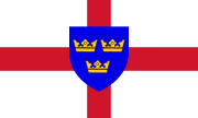
The East Anglian flag as it is known today was invented by George Henry Langham and adopted by the London Society of East Anglians. It was first mentioned in print in 1900 and was flown locally in various places in Norfolk, but has no official status.
It draws upon the coat of arms of the Wuffingas dynasty: three crowns in a blue shield, the colour of the Swedish flag, superimposed on a St. George's cross. The device refers to an old legend of the three crowns of East Anglia, and the blue colour represents the Anglo-Scandinavian heritage of much of East Anglia.
The crowns also appear in the arms of the borough of Bury St. Edmunds and the University of East Anglia.
See also
- Kings of East Anglia
- Earls of East Anglia
- Roman Catholic Diocese of East Anglia
- University of East Anglia
- East Anglian Brigade
- East Anglian English
References
- ↑ Hierarchical list of the Nomenclature of Territorial Units for Statistics and the statistical regions of Europe The European Commission, Statistical Office of the European Communities (retrieved 26 February 2010)
- ↑ Fisher, David Hackett Albion's Seed: Four British Folkways in America Oxford University Press, 1991
- ↑ Pillboxes UK Ian Sanders, December 2005
- ↑ Brown, Chris State of the Environment Report 1998 Chapter 11: Physical Background (pp.305-306) Cambridgeshire County Council (retrieved 19 July 2007)